Views of Canterbury
1851
 William Holmes (1825-1885) a schoolmaster,
was a Fore Cabin Passenger (intermediate) on the "Castle Eden". He
arrived February 1851 to take up his position at the newly formed
Collegiate Grammar School in Lyttelton. It opened on 6 January 1851 under
Rev. Henry Jacobs and William Holmes who had gained his position partly
for his ability in music and art. Within weeks of arriving he was active
with his pen and pencil and was also making plans to publish sketches of
Canterbury. By December 1851 many were being made available for private
viewing at the Steadfast Coffee Room, Lyttelton, Four sketches were
eventually published in C.W. Adams "A Spring in Canterbury" 1853 and
others were issued as single line engravings printed in London. "I propose
that my sketches be published in large 8vo. in this style with a little
descriptive letterpress to be called Canterbury sketches & sold in a
wrapper at a small amount, say 2/- or 2/6 or such a price that the poorest
emigrant might afford. This will then afford great benefit both to the
Assn & the colonist." N.B. To be got up in plain outline. William
Holmes, Grammar School- Lyttelton- March 1851.
Source - Hocken Library, Dunedin: "I propose that my sketches be published in
large 8vo. in this style with a little descriptive letterpress to be
called Canterbury sketches & sold in a wrapper at a small amount, say
2/- or 2/6 or such a price that the poorest emigrant might afford. This
will then afford great benefit both to the Assn & the colonist. N.B.
To be got up in plain outline." William Holmes, Grammar School, Lyttelton,
March 1851. (The above key & the sketches to which they refer, with
the exceptions of Nos 5, 6, 9, 10 & 11 which were not sufficiently
worth copying, are copies of the originals lent to me by the Rev
Prebendary Jackson, 29 Mecklenburg Square, London, a prebendary of S.
Paul’s Cathedral London & a son of the Rev. Thos Jackson, Bishop
Designate of Lyttelton. Mr Holmes accompanied Bp Des. J. out to Canterbury
& was a schoolmaster of the Assn I have had the copies lithographed.
The Assn got into so much pecuniary difficulty that it was doubtless
impossible to comply with Mr Holmes request to have these sketches
published. T.M.Hocken, London Dec 15
1903).
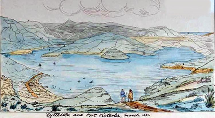
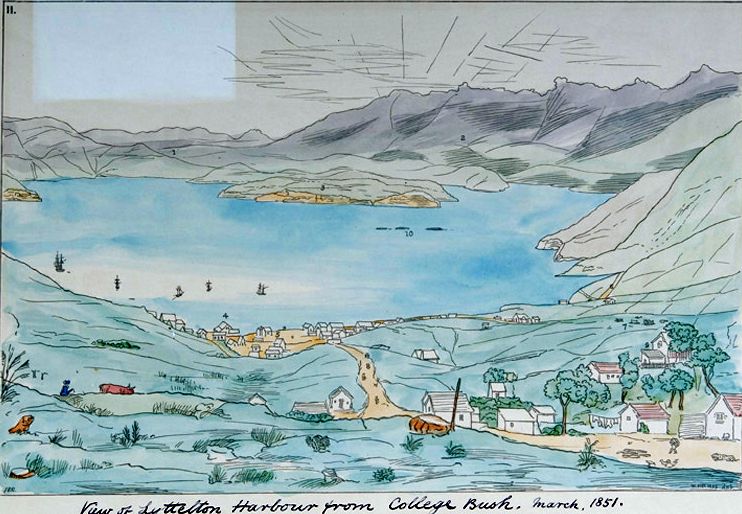
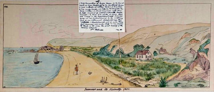 Sumner and its vicinity:
Label by W. Holmes transcribed in ink by Dr Hocken: 1. Rhodes’s
farm, Banks Peninsula. 2. A native Pah. 3. Pulao Bay. 4. Castle Eden , 930 tons; 5. Sumner Road; 6.
Town of Lyttelton; 7. Port Victoria; 8. Quail Island (abounding in good
building stone); Wm Holmes. N.B. 10.
Shag Reef.
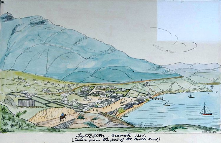 1 Cross set up on
part of Mt Pleasant by the 1st masters; 2 H.W. Russell Esq.; 3 London
St.; 4 Jail (building); 5 J.R. Godley Esq. C. Assoc’s Officer; 6 Lyttelton
Times Office; 7 Temporary Church & Schools; 8 Sumner Rd.; 9 Dr
Earle’s; 10 Isabella Hercus; 12 Maoris encamping. 13 Temporary Epis.
Palace; 14 Association's store; 15 Pier; 16 Esplanade; 17 Mr Alport’s
store; 18 Longden & Le Cren’s store; 19 Lyttelton Arms Hotel; 20
Mitre. Major Hornbrook’s; 21 Oxford; 22 Sumner Parade, joining London St.;
23 Canterbury St.; 24 Bridle Road, joining esplanade; 25 Market (site of
the) 26. 27. 28. 29. Emmigration Barracks. N.B. Taken from foot of the
Bridle Road. Wm Holmes.
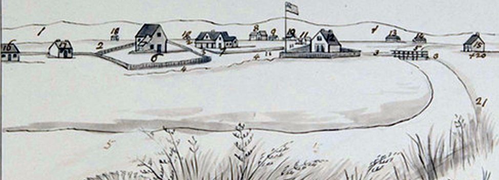
 Margin below image in ink in Dr
Hocken’s hand: Town of Lyttelton March 1851 T.M. Hocken; label: Na Te
Hakena Tenei Tiki; note by W. Holmes transcribed in ink by Dr Hocken: 1
College Wood; 2 1600 feet high; 3 Direction of Bridle Road;
4 Lyttelton Rectory (Rev. Mr Dudley);
5 J. Townsend Esq.; 6 H.W. Russell Esq.; 7 Mr McFarlane;
8 Road to cemetery; 9 London St.; 10 Canterbury St.;
11 Mitre; 12 Esplanade; 13 Lyttelton Arms Hotel; 14 Longden
& Le Cren’s iron store; 15 Mr Alport’s store; 16 Lyttelton Times
Office (Mr Shrimpton’s.); 17 Association’s store; 18 Pier; 19
Boathouse; 20 Temporary Episcopal Palace; 21 Part of
Emigration Barracks; 22 J. R. Godley Esq.; 23 Dr Earle;
24 Sumner Parade; 29 Port Victoria. Wm Holmes.
T.M.H.
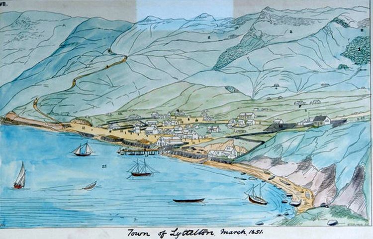 View of Lyttelton from above looking out to the
harbour, with Quail Island on the right, Diamond Harbour and Mount Herbert
straight ahead. Sumner Road is on the left and the immigration barracks,
John Robert Godley's house and the Esplanade marked with
numbers.
Margin below image in ink in Dr
Hocken’s hand: Town of Lyttelton March 1851 T.M. Hocken; label: Na Te
Hakena Tenei Tiki; note by W. Holmes transcribed in ink by Dr Hocken: VII.
College Wood. 1600 feet high. Direction of Bridle Road. Lyttelton Rectory
(Rev. Mr Dudley) J. Townsend Esq. H.W. Russell Esq. Mr McFarlane. Road to
cemetery. London St. Canterbury St. Mitre. Esplanade. Lyttelton Arms
Hotel. Longden & Le Cren’s iron store. Mr Alport’s store. Lyttelton
Times Office (Mr Shrimpton’s.) Association’s store. Pier. Boathouse.
Temporary Episcopal Palace. Part of Emigration Barracks. J.R. Godley Esq.
Dr Earle. Sumner Parade. Port Victoria. Wm Holmes. T.M.H.
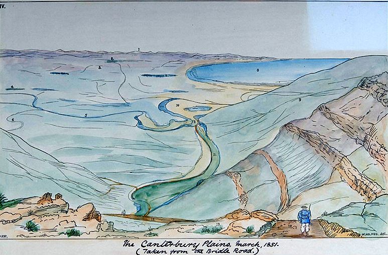
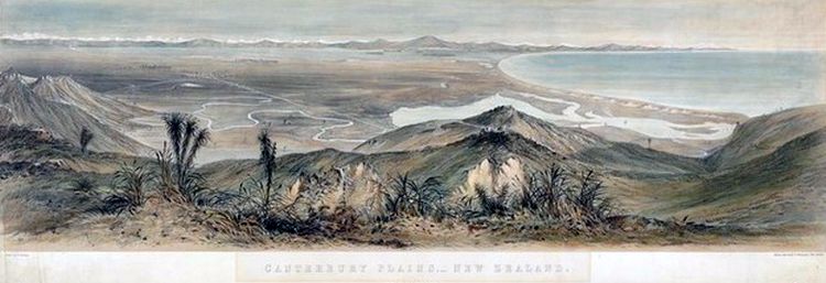
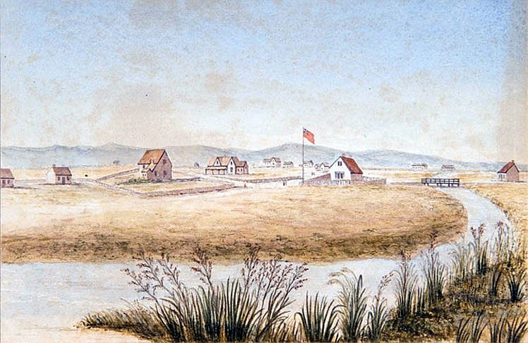
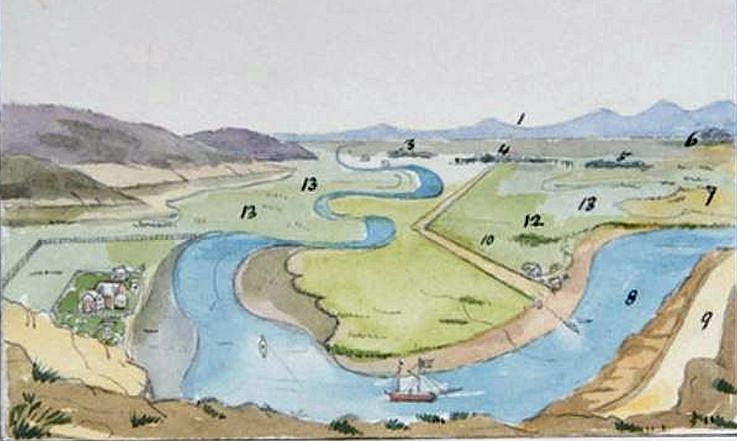 Canterbury Plains from the
Heathcote River: Margin below image in
ink in Dr Hocken's hand: 1. Southern Alps Snowy
mts, distant 100 miles; 3 Riccarton Bush; 4 Christchurch; 5
Papanui; 6 Harewood Forest; 7 Sandhills; 8 Heathcote river; 9
Road to Lyttelton; 10 Road to Christchurch; 12 Townsend's house; 13
Swamps. Wm
Holmes
Sailing ships began
transporting goods from Lyttelton. First they had to sail through the
shifting sands of the Sumner Bar, and long delays, or worse still
shipwrecks, were common.The Heathcote was tidal for eight miles, but the
sharp bends, the wind from the hills and the swamp flats made navigating
difficult. To assist the ships a towpath 25 feet wide was built on each
side of the river. Bullocks and horses pulled the ships through the most
difficult sections, except where the ground was too swampy for the animals
to walk across it. Rowing boats from the larger vessels pulled them
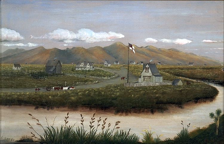
through these stretches.Wharves were built on the north
side of the river and industries were established with river access. One
wharf was near the point where the Steam Wharf Stream joins the Heathcote.
Here there was room for the ships to turn and the Steam Wharf became a
busy port. Cargo was taken to the town by carts and drays pulled by horses
or bullocks. Once the railway to Ferrymead was opened in 1863 and the
Lyttelton railway tunnel was opened in 1867 the role of the Heathcote in
transport diminished greatly. Drawing from the Hocken Library
A ferry service across the Heathcote river was established in 1850 and operated under a succession of ferrymen until displaced by a bridge in 1864. Although it was possible to cross the Heathcote further upstream, the ferry lay on the main route of travel from Lyttelton to Christchurch. The original crossing point was under the present road bridge. In 1852 the site of the ferry was moved 400 yards upstream closer to Ferrymead House. The shingle which was laid down to give a firm footing is still visible at low tide. A cart service was available to transport passengers from the base of the Bridle Path to the ferry along the route of the modern Bridle Path Rd. The most direct route to the city was via Ferry Rd. In early 1851, one hundred labourers were employed to make Ferry Rd fit for traffic. Construction was completed before the end of the year. In 1852 Beresford's Royal Mail cart, the first public passenger vehicle in Christchurch, began carrying passengers between the town and the ferry, but in the early stage of settlement, foot traffic still dominated. 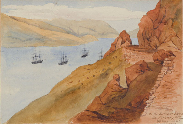 Artist Wm Fox: Lower right
written with brush: On the Sumner Road, Canterbury, NZ. Jan.1851; On
sketchbook mount: On the Sumner Road, Canterbury 1851; on flypage of
sketchbook in ink: Thomas Morland Hocken from Sir William Fox. Sir William
Fox who well the interest I took in old New Zealand & was a
frequent visitor at my house, promised to bequeath me these sketches which
he commenced to take from the time of his arrival in New Zealand in
1842.
 |