Click Slide menu on left Click Slide menu on left THOMAS
SKITTERELL (1707
- 1791)
Thomas Skitterell (b: 1707 in Burbage, Wiltshire,
England, he was the son of Thomas Skitterell (1642- ) and mother
Catherine nee Pearce) He d: a pauper and was bur: at Burbage,
Wiltshire 16 Mar 1791

Thomas Skitterell mar: 17 Jan 1730/31 in
Burbage, Wiltshire, England to Jane Hazel (b: 08 Mar 1707/08 in Burbage, Wiltshire
to her parents John Hazel and mother Sarah nee Nutley; she d: 28
May 1774 in Burbage where she was bur: 30 May 1774) Their
children:
1 Sarah Ann Skitterell (bapt: 05 Sep 1731 in Burbage,
Wiltshire, England; d: 23 Sep 1780 in Burbage, Wiltshire Bur: 24 Sep
1780 Burbage , Wiltshire, England) mar: George
Cox
2 Mary Skitterell (b: 19 Aug 1733 in Burbage ,
Wiltshire, England; d: 18 Apr 1803 in Burbage, Wiltshire, England)
3 Elizabeth Skitterell (b: 17 Dec 1735 in Burbage ,
Wiltshire, England; d: 23 Apr 1741 in Burbage , Wiltshire, England)
4 Jane Skitterell (bapt: 05 Nov 1737 in Burbage,
Wiltshire, England; d: 13 Apr 1803 in Burbage, Wiltshire, England; Bur:
13 Apr 1803 Burbage, Wiltshire, England) mar: John Eagle
5 Thomas Skitterell jnr (b: 19 Oct 1740 in Burbage ,
Wiltshire, England; Bapt: Nov 1768 Burbage; d: 26 Oct 1828
in Burbage, Wiltshire, England mar; Elizabeth
Besant
6 Rebecca Skitterell (Bapt: 04 May 1743 Church of England, Burbage,
Wiltshire; d: 25 Dec 1810 in Burbage, Wiltshire Bur: Burbage)
mar Thomas (Gulliford - sp) Guilford
7 John Skitterell (Bapt: 23 Feb 1745 Burbage; bur: 7 Jul 1770 Burbage)
*2nd Wife of Thomas Skitterell: Mar: 24 Oct 1782
to Sarah Perry (b: 15 Sep 1731 in Burbage,
Wiltshire)
|
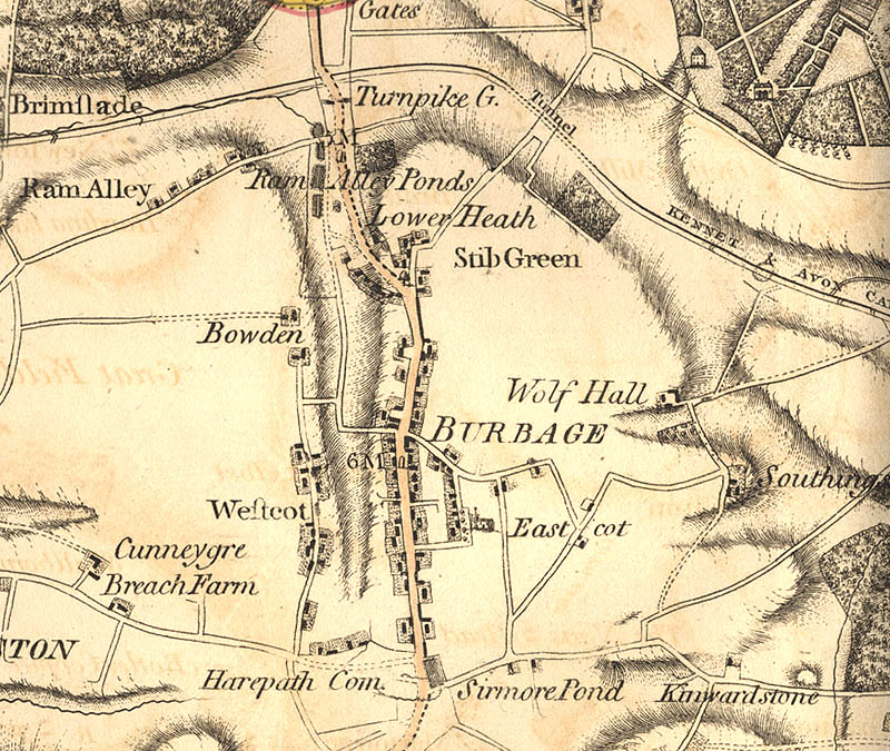
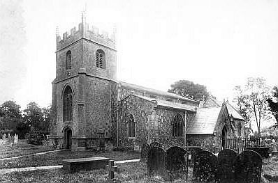
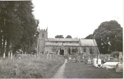
HISTORY: The parish of Burbage lies to the
south of Savernake Forest, and is of roughly rectangular shape, with
the villages of Burbage and Durley, the hamlets of Stibb Green and
Ram Alley, and various outlying farms. In The main village is
Burbage, which was originally three strips of ribbon development,
Westcourt, Burbage and Eastcourt, which were based on early estates.
Durley village was planted on about 230 acres of rough pasture
belonging to Burbage. There are now many Savernake estate houses in
Durley.
There appears to have been little occupation of this
area until Saxon times although artefacts from the Neolithic and
Bronze Ages have been found, Iron Age pottery shards were unearthed
at Godsbury and objects from a Romano-British grave found in the
south of the parish. The Roman road from Cirencester to Winchester
via Mildenhall (Cunetio) crossed the north-eastern corner of the
parish. Most of the names derive from Saxon and it is most likely
that much of the area was forest until then. Durley means a clearing
in the forest, while the name Burbage indicates a fortified place on
a ridge. Burbage is first mentioned by name in a charter of 961 but
it is the ridge rather than the village that is referred to. There
was an estate called Burbage in the 11th century and as there was a
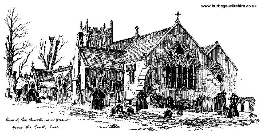
church and priest in the latter part of the 12th century it is
fairly safe to assume that a village existed by the end of the 11th
century.
When the Domesday Book was complied in 1086 there
were three estates here and a virgate (between 20 and 30 acres) of
land for the priest. The size of the three estates was similar in
size. Blacheman, whose name is remembered in Blackman's Lane, held 2
1/2 hides of Humphrey de Insula and this was the most valuable of
the three at 40 shillings. The other two were held by servants of
King William; Richard de Sturmy, whose descendants held Savernake,
had 2 1/2 hides, later Westcourt Manor, while Ralf de Haluile had
two hides of land. Both estates were worth 30 shillings. There were
only 15 families living on the three estates and the total
population would have been in the range of 57-67 at this time. Small
amounts of woodland survived on each estate and there was meadowland
at Westcourt. Arable land in the common fields supported 6 1/2
ploughteams of oxen.
All the estates were within Savernake
Forest and were all later held by the Sturmey family. By the early
13th century the important Marlborough to Winchester road passed
through the parish, probably along the present High Street where the
deep banks on either side bear witness to the eroded greensand
caused by many centuries of traffic. Settlement would have grown up
on either side of this road, which bypassed the church at Eastcourt,
creating three lines of north to south settlement. Settlement at
Westcourt was associated with the site of an early manor house while
Eastcourt was probably the priest's land. In the early 14th century
it was noted that there was extensive open fields and these would
have covered between 1,000 and 1,500 acres. The whole parish, except
Southgrove Copse in the south was disafforested in 1330. There had
been little woodland for at least three centuries but now the area
was no longer subject to Forest Law.
No mill was recorded in
the Domesday Book and there was probably little surface water. By
1349 there is a miller, who must have dammed one of the streams to
collect enough water overnight to power his wheel. The number of
poll tax payers (people over 14 years of age) in 1377 was 107, a
reasonable number for this period. In 1427 Burbage passed by
marriage to Sir John Seymour and has remained in the Seymour, Bruce,
Brudenall, and Brudenall-Bruce families ever since. From 1450 land
in the open fields was enclosed and sheep were important in the
parish with grazing allowed in Savernake Forest for the tenants of
both Burbage and Durley. These rights had completely disappeared by
1847.
From the 16th century the course of the main
Marlborough to Salisbury road was altered and it now passed along
Burbage High Street, providing increased traffic and possibly more
custom for the ale house. Land was enclosed at Durley from 1574 and
two rabbit warrens existed here. The name Ram Alley was first
recorded in 1632 and the settlement doubtless came about from
cottages that were built on the waste land. We do not know what
early cottages fronted the High Street but some timber-framed ones
from the 17th century survive there and also at Eastcourt. John
Aubrey wrote that good turnips and peas were grown in the parish in
the mid 17th century.
The
origins of Stibb Green were in cottages built on wasteland around a
triangular green. By 1711 the Duke of Somerset's Arms was open here,
it was later called the King's Arms and closed between 1859 and
1867. Open land had been enclosed since the mid 15th century and in
1721 the remaining 922 acres of open fields were enclosed. The road
through the parish remained an important one and was turnpiked in
1762. Durley stayed the quiet settlement, close to the Forest with
dwellings along the north to south street, with more cottages to the
west. There seem to have been a fair number of paupers in Burbage
parish in the latter part of the 18th century, among them Thomas
Skitterell. A workhouse was established by around 1774 and paupers
living there worked at spinning and laundering. Much of the help
provided was outdoor relief, helping people living in their own
homes. In 1794 the parish bought 74 spinning wheels for people to
spin hemp in their houses.
Commercial activities and services
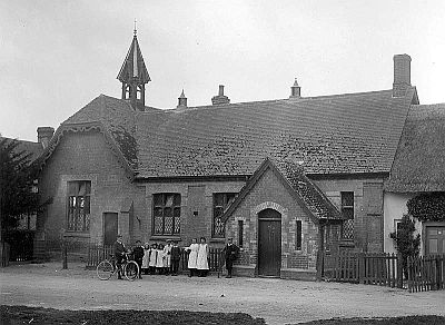
provided increased during the 19th century. A school was established
in 1806 and by 1833 there were two schools here. In 1809 the Kennet
and Avon Canal, passing through the 502 yard long Bruce Tunnel was
opened in the northern part of the parish. Burbage Wharf was
probably built around 1810 when the canal was fully open providing a
waterway from Bristol to London. A revolving wooden crane (now
restored) was built at the Wharf in 1831. With its own wharf Burbage
would enjoy products such as coal and slate that could not be
obtained locally, and also had a means of transport for its
agricultural produce. Bricks and tiles were made here in the 19th
century. The remaining common land, 213 acres, was enclosed in 1824
and by 1840.
Throughout the first half of the 1800's Burbage
was able to support a good range of shops, crafts and trades. The
parish became part of the Pewsey Poor Law Union in 1835 and was able
to send its pauper inhabitants to the workhouse in Pewsey, a
retrograde step for those involved as they would have preferred to
continue being supported in their local community. By the 1820s
there were two new public houses in the High Street. The Cleaver,
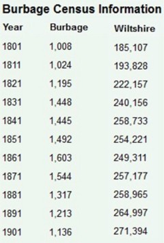
which had closed by 1859, and the White Hart. Population peaked in
1861 but this figure was inflated by the men who were building the
Berks and Hants Extension Railway Line living in the parish at the
time of the census. The railway was opened in 1862, as a part of the
Great Western Railway network with a station at Savernake and one in
Burbage, near the canal wharf. Today this is the Exeter to London
main line. In 1864 a branch line to Marlborough was built to the
west of Savernake Station; this line closed in 1933. In 1818 the new
Swindon to Andover Railway line was built across the parish creating
a second station at Savernake.
By 1875 the New Inn, later the
Bullfinch, had opened in the High Street and from 1880 until at
least the Second World War the Red Lion beer house was open; it
later became a restaurant. In the late 19th century the Three
Horseshoes opened as a beer house at Stibb Green, later gaining a
full licence.
Village population decreased for nearly 100
years from 1861. In the first half of the 20th century any new
building was largely council housing for rural workers, replacing
cottages that had few facilities and were in poor condition. In
1926/7 fourteen houses were built at Eastcourt while in 1936 a
further twelve were built on the eastern side of the southern part
of the High Street. A village hall had been erected in the 1920s and
in 1928 the White Hart was rebuilt. Having lost its canal traffic in
the mid 19th century Burbage suffered a further blow to its
transport services when the railway station was closed in
1941.
Village population reached its lowest point in 1951 but
from then onwards, and especially from the 1960s, the village has
seen substantial expansion. From around 1950 to 1974 sixty-two
council houses were built, mainly to the west of Eastcourt Road.
From around 1970 to the mid 1990s over 100 private houses and
bungalows were built between Eastcourt Road and the High Street.
Building continued in the late 20th century with infill between the
older houses in the High Street. Although most shops and many local
businesses disappeared during the 20th century stables at Westcourt
were used for racehorses and from 1981 were used as kennels for the
Tedworth Hunt. Two very beneficial events concerning transport
occurred in the 1990s. In 1991 the Burbage bypass to the west of the
High Street was opened relieving the pedestrians of the High Street
of much of the danger of negotiating its length with little in the
way of pavements. This has possibly been the greatest beneficial
event for the village since the road was turnpiked over two
centuries earlier. Of lesser importance was the re-opening of the
restored canal bringing the economic benefits of increased tourism
to the area.
Src: Wiltshire Council
|
|
|
|
|
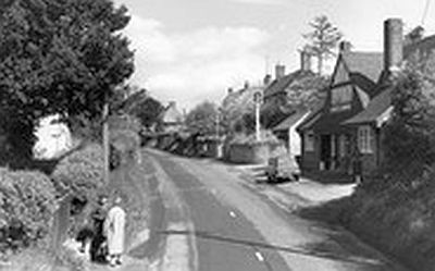
1962 - Burbage High Street |
Images and data used in this site
copyright - ©
Descendant input to up-date family pages
is very welcome - more detailed information available on request.
|
|